Upload failed. Maybe wrong permissions?
startSectionEdit: $data "section" is NOT an array! One of your plugins needs an update.
1 Planet Specification Format (PSF)
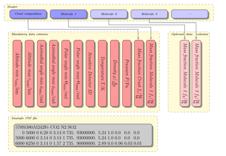
The idea is to define the atmosphere specification in a robust way, which is both future proof and misinterpretation-proof. The main characteristics of the format are:
- The format specifies the atmosphere as one sheet per line. The number of lines specifies the number of atmospheric sheets.
- The format also includes a polar and azimuth angle variability to make it future proof.
- Please don't limit the number precision and use scientific notation!
- Sum over all mass fractions is equal to 1.00.
- The above does not include the soil column. The soil column should be set to one for the soil and crust volumes.
- The sensitive detector ID (SDID) is an integer quantity. 0 and 1 are reserved for core and crust.
- Please always include a core and a crust
- The atmosphere should be built from the bottom up, starting with the SDID 2.
- Don't skip SDIDs.
- Header: The header is ment to specify the soil composition(column 10) and also to name the material whose contribution is specified in one of the columns designated with 11,12,13. Example:
#578Si380Al242Fe CO_2 N Ar
Note: you can use materials available in the Geant4 NIST material database. Leave out the prefix “G4_$. If your gas molecule is not available, you can specify it as an artificial mixture. For example, SO2 would be 50.05% Sulfur and 49.95% Oxygen (in terms of mass fraction). The error of this approximation is discussed here.
- Unlimited header lines are possible, as long as they start with ”#“, they will not produce an error in the data analysis
- The first entry tells AtRIS that the soil is 578 parts Si, 380 parts Al, 242 parts Fe.
- The following entries specify what materials do the individual columns specify.
- Example:
| Column nr | Name | Long Name | Unit | Range | Type, Notation |
|---|---|---|---|---|---|
| 0 | alt_low | altitude at bottom of the layer | km | 0- | %12e |
| 1 | alt_high | altitude at top of the layer | km | 0- | %12e |
| 2 | phi_low | azimuth angle start | rad | 0-6.2831853 | %12e |
| 3 | phi_high | azimuth angle stop | rad | 0-6.2831853 | %12e |
| 4 | theta_low | polar angle start | rad | 0-3.14159265 | %12e |
| 5 | theta_high | polar angle stop | rad | 0-3.14159265 | %12e |
| 6 | SDID | (0=core,1=crust), 2,3,… | 0-666 | %4i | |
| 7 | Temperature | K | 0- | %12e | |
| 8 | Density | $\rm{g}/\rm{cm}^3$ | 0- | %12e | |
| 9 | Pressure | hPa | 0- | %12e | |
| 10 | Soil | Mass fraction of soil | $\%\,(\rm{kg}/\rm{kg})$ | 0-1.0 | %12e |
| 11 | $\rm{CO_2}$ | Mass fraction of CO2 | $\%\,(\rm{kg}/\rm{kg})$ | 0-1.0 | %12e |
| 12 | $\rm{N_2}$ | Mass fraction of N2 | $\%\,(\rm{kg}/\rm{kg})$ | 0-1.0 | %12e |
| 13 | $\rm{Ar}$ | Mass fraction of Ar | $\%\,(\rm{kg}/\rm{kg})$ | 0-1.0 | %12e |
- In this example, we have:
- first 6 columns defining the geometry of the planet element
- one column holding the SDID
- 3 columns containing the macroscopic quantities.
- 1 column for soil material specification
- 5 columns containing gasses from G4's NIST database
- Since the angular quantities are stated in terms of radians, a spherical shell should set theta_low=0, theta_high=3.14159265, phi_low=0, phi_high=6.2831853
- All altitudes should be measured from the center of the planet. This is important when scaling the simulated flux with a real flux. Therefore, the core volume should have alt_low=0km, alt_mid=6365.0km
- The user should ensure that there are no gaps between the volume elements of the planet.
- Particles are not tracked within the core.
- Shell particles are tracked in order to allow for surface albedo particles. Reducing the shell thickness to a “good-enough” minimum improves performance. I use 20m.
Examples files
- Example one.psf and the resulting one.gdml file - this file has been obtained using the nrlmsise00 interface.
- Example two.psf and the resulting two.gdml file - this file is used to illustrate the differences between Geant4 NIST materials and material mixtures. See error_of_mixed_materials for more info.
- Example icru.psf and the resulting icru.gdml file - this file has been used to simulate the effects that radiation has on an ICRU water ICRU spherical phantom with shielding applications.
The gdml files are created using the psf2gdml.py script. Note that the .psf files offers advantages for human use, since it is much easier to read. 1)
1)
The specified number format has not been used, since we wanted the examples to be illustrative of the general features.
